packing my gear to head off to West Wales. Weighing up the
weather and the time it would take to get there I called it off
last minute. Instead I settled for a paddle out from Llantwit
Major an hour or so after high tide and take the spring ebb
toward Porthcawl.

Immediately I was accelerated to 7kts across Llantwit beach
over the underlying rocky outcrop which extends out from
the beach. I headed into a westerly wind which made it feel like
quite a task to paddle even though I was making a steady 5-6kts.
I thought that low angle paddle I tried out last week at the Welsh
Kayak Show would be nice now.

In no time at all I was at Nash Point. There was no trouble
reaching the East Cardinal Buoy today as I flew past at over
8kts! The buoy straining at it's moorings.

The waters seemed much calmer now along the cliffs reaching
toward Southerndown after the confused racing currents around
Nash Point.


this rock!
out jets of water. I reached Ogmore by sea and could clearly
see Tusker Rock so I made a short ferry glide over for some
lunch.
until 15:00. The rock is absolutely littered with bit of iron from
the ship wreck. This tank made a pretty eerie gargling sound
as the tide drained out of it's holes.


aimlessly at the rock I noticed it moving. It was covered in
thousands of sea snails all moving around like chess pieces
in quick little bursts.
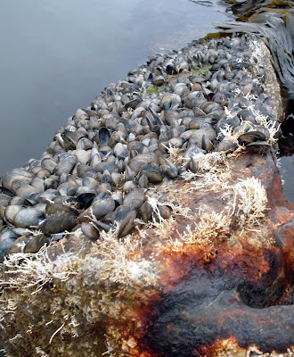
by now so I decided to explore this living museum.


limpets, muscles and coral all hung on.


This looked like an old chain perhaps for the anchor?
walk to launch again. I was surprised how big the rock
actually was, probably because it was such a big spring tide.
I spent an hour on shore and still didn't get to the far side.

Looking out toward Ogmore by Sea.

the mid nash buoy some 4 or 5 kilometers off shore so made
a bearing for it. As I got further out the sea was a bit choppy.
The tide was only now carrying me at 2.5kts. I thought by the
time I get there the flow will be in full force so made a beeline
for nash point.
Flying past the east cardinal buoy this time at 7kts.
Landing at Llantwit Major beach with a bit further to walk
than earlier. A good day out at 30km or 16.5 nm. Top speed
on my GPS 8.2kts! Going home now for a long soak in the
bath to sooth those aching muscles!
Thanks to anyone who reads my blog. Met a few people at
the Kayak Show last weekend at Up & Under, was a bit shocked
when people were asking if I was Stuart. Thanks guy's, and sorry
to disappoint but the sheep didn't jump! Cheers.


7 comments:
Hi Stuart,
I have started my own blog (deenno22.blogspot.com) and was wondering where I can get the map from.
Derek (Pilot boat crew)
Thanks Stuart, www.walkhighlands.co.uk/maps did it for me.
Your Tusker rock trip looks good, what camera are you using? I have a digital in a Aquapac, its a bit naff to use.
Derek (Pilot Boat Crew)
I'm just using a digital at the moment it's not waterproof. I tried using an Aquapac but kept getting blurry pictures. Richard uses a Pentax Optio W80 which is water proof and his pictures look great. Just another piece of equipment to add to the wish list!
That was terrific, Stuart. I grew up in Bridgend, and spent many hours down at the beaches at Ogmore and Southerndown, so have always known of Tusker Rock. I have vague memories of a shipwreck there when I was very young, but I may be imagining it! I certainly knew there had been a major wreck on the rock, but your photos are the first time I've seen anything about it anywhere, so thanks for that!
I never knew of the ship wreck, interesting stuff
hope this helps about the ship wreck
https://en.wikipedia.org/wiki/SS_Samtampa
I spent a lot of time at Ogmore by Sea in the 40's when I was young. It was suggested to me that an American boat sunk on Tusker during the war. The crew were allegedly all drunk. It is a treacherous water to sail on with the 40 foot rise and fall of the tide changing the clearance of hazards like Tusker Rock very significantly. There was an old handed down story which suggested that in the middle ages that sheep were grazed on Tusker but I've no idea whether there's any truth in that. There had been a lighthouse at the rivermouth too which burned down and, also a Marriat? cafe built from the timbers of a ship wrecked on the rocks. It burned down in the late 40's I think. There were chalets/shacks made from galvanised sheeting near the beach but with electricity supplied by overhead cables the storms caused the cables to break and set fire to the chalets until they all disappeared. Friends of mine were lucky to survive when their chalet went up in smoke.
Post a Comment