The long wait to return to the Isle of Skye had final come but the remains of Hurricane Katia looked set to spoil our plans. Sever strong gale warnings flashed over most of the north west of the country with unsettled weather set for the remainder of the week ahead. We put off traveling up on Saturday and kept a close eye on the forecast. We made the decision to go for it and travel up first light Sunday.
We spent the Sunday night in the back of my van in the shadows of Ben Nevis in Glen Nevis. It seemed they were preparing for the worst as sever gale force winds threatened throughout Monday afternoon. There was speak of 50ft high seas on the radio, all ferries grounded and bridges closed. We woke early hoping to reach Skye Bridge before they closed it.
MONDAY 12th SEPTEMBER 2011

 We continued our little trek keeping our eyes peeled for eagles, well known to nest along these cliffs.
Just as our clothes were drying off the heavens emptied again as we tramped through a very boggy field back to a waterlogged camp site. I decided to stay in the comfort of my van for the remainder of the week while my dad braved the damp conditions in the tent. Not before testing out the local beer/whisky of course!
TUESDAY 13th SEPTEMBER 2011
We awoke to another damp and breezy day. It seems the gale force depression had passed further south across lower Scotland and Northern England and Wales. Conditions for today were still bleak so I decide to take some advice from the guys on the forum and head for a trip around Scalpay, a fair size island not far from base camp on the east coast.


Ferry terminal at the south of Raasay
With the wind at my back I made a good 6-7 knots across the 3 1/2 km crossing to the Isle of Raassy. I paddled around the southern extremities of the island before crossing over to Scalpay.

My photos are much to be desired on such a bleak day but I've added them all if only for my own purpose.

The cloud continued to gather from behind until I was almost lost in a sea of mist.


Shelter on Scalpay, Rassay in the distance.
Continuing east as I reach Scalpay for a clockwise circumnavigation I find a small sheltered bay on the north of the island to plan out my trip ahead out of the wind.

There isn't much to see on Scalpay, made even more grim with the weather. Apparently it is a privately owned island that operates a red deer farm, shooting estate and holiday cottages. It is a fairly low lying island (compared to the heights of its surroundings) made of mainly moorland and conifer plantations.

I take the opportunity to look back across to the remote eastern side of Rassay, a trip three day circumnavigation I hope to make someday, a comment I believe I made last year.

The east side of Scalpay looks on to a series of smaller islands. I was tempted to paddle the short distance out and link them up before crossing back but the wind was on the increase and I had to be back for my dad.

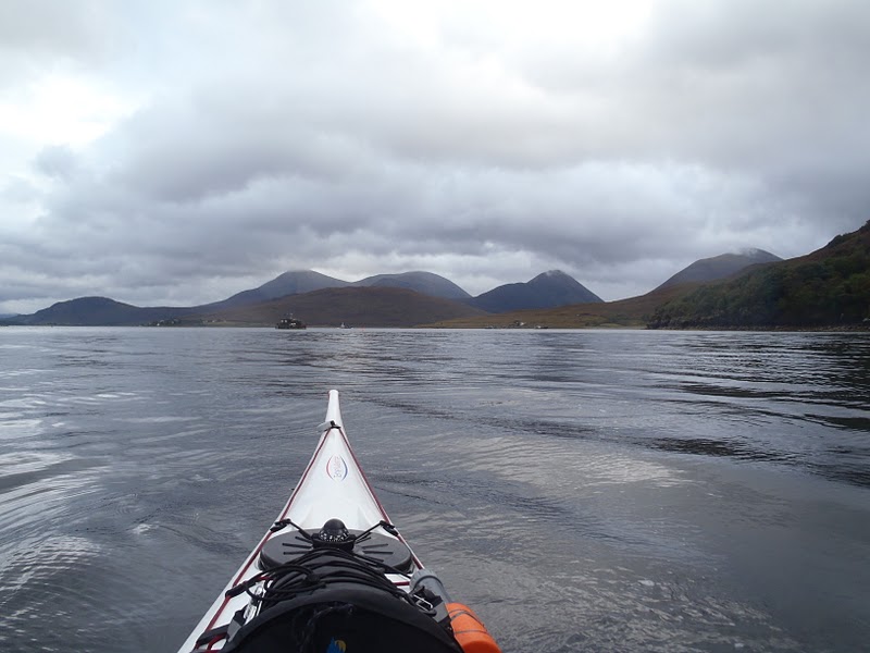
Under the cliffs of the south east of Scalpay I was out of the wind. The inshore waters take on a mirror like appearance in a brief spell of calm as I try to make out land far across Skye's inner sound.


I find a long awaited sheltered spot on the far side of Loch Ainort after a grueling crossing. I dip into my deck bag for some energy snacks before pressing on.

Around the last headland and it was a final push into Loch Sligachan. By now I was faltering, energy sapped and joint aching I was tempted to get out and walk. There was no stopping, a brief stop would have me stalling and blown backwards.

The pier was now in view, a meir 1/2 km push to finish. I stop again behind a small slipway to a hotel as the Raasay ferry drives past. I let it pass as we are going to the same destination and drive in behind it's wake.

I crash out on the beach, barely able to walk and completely out of breath. Has to be probably the hardest paddle I have done. A kind lady who must have seen my struggle from the ferry offered to help me up to the car park with the boat. I thank her between breaths and notice as she drives away the v-bars on her car roof, a fellow kayaker.
I load the boat and head on up to the pub, over an hour late. An eagle sores over the loch above, but no energy to get my camera out of the back. I find my dad, should I say slightly tipsy, after he had come of the hills four hours earlier. The rivers had turned into torrents due to the rain and he was unable to cross them.
17 nautical miles in total (roughly 31km/20miles)
5 comments:
Bit Jealous here Stu, fancy circumnavigating Skye???
Thought about getting out and walking! Nice one!
Looked like a nasty day, but all good.
Taran i would love to a week of perfect weather and a group to split the petrol i would do it.
Mart i was very tempted to walk. Like tour trip to pembrokshire, you just have to make the most of it.
More to follow shotly.
Sounds like a plan though I'm not sure about the week of perfect weather. Does that ever happen???
Great photos well at least there were no midges!!!!!
Post a Comment